Categories
Announcements Projects SoundTiles Sparus II

#PLOMEproject: testing innovative technologies for the management of marine ecosystems

The PLOME project has tested new technologies that will allow the deployment of stations and vehicles to monitor the marine environment and provide real-time data. The experiments have been conducted along the Catalan coast at depths of up to 350 meters. The project is led by the University of Girona, with participation from the UPC, the UIB, the UPM, the ICM-CSIC, and the company Iqua Robotics.

An oceanographic campaign has validated this past December a set of innovative technologies developed within the framework of a research project coordinated by the University of Girona (UdG) with the aim of improving the supervision, monitoring, and management of marine ecosystems. The campaign took place aboard the oceanographic vessel Sarmiento de Gamboa, of the CSIC, off the Catalan coast, at depths ranging from 70 to 350 meters.

The research project is called “Long-Term Platform for the Observation of Marine Ecosystems (PLOME)” and is comprised of six partners: the University of Girona (UdG), the Universitat Politècnica de Catalunya – BarcelonaTech (UPC), the University of Balearic Islands (UIB), the Polytechnic University of Madrid (UPM), the Institute of Marine Sciences (ICM-CSIC) and the company Iqua Robotics.

The PLOME project, funded by the Spanish Research Agency and Next Generation European funds, is working to develop a non-invasive and modular platform to gather essential data for the scientific community to supervise, monitor, and manage marine ecosystems more efficiently. So far, a set of independent systems has been developed, consisting of fixed stations that remain on the seafloor, underwater vehicles, and surface vehicles. These systems are equipped with batteries and wireless communication systems, and they work together autonomously to collect data.

Currently, data extraction can only be predominantly carried out when a human team conducts an oceanographic campaign. The project aims to advance this information gathering system. Thus, the PLOME platform allows remote monitoring without the need for human intervention once the systems have been deployed on the seafloor, over a period of several weeks, with real-time communications facilitating ecosystem tracking.

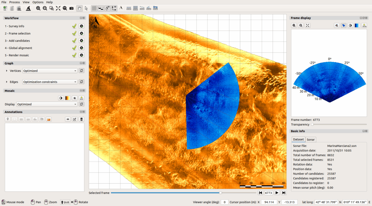
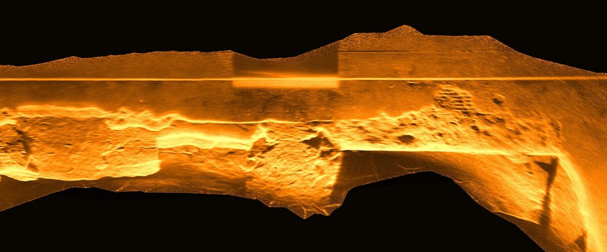
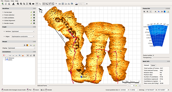
During the December campaign, two fixed stations, two underwater vehicles, and a surface buoy were deployed to transmit information, which served to validate the operation of the various technologies developed since the beginning of the project. The systems communicated correctly using acoustic modems to share data and optical communication to share images. The cameras, installed on each system, recorded data from the seafloor and simultaneously processed it using artificial intelligence techniques to detect the presence of individuals such as fish or crustaceans. New technologies for optical and acoustic mapping of the seafloor were also validated, allowing for the reconstruction of terrain or acoustic visualization to reduce the impact of artificial light in habitats where sunlight does not reach.

The test results were successful, and work is already underway on the next validation campaigns of the project. The next one will take place at OBSEA, the UPC’s cabled marine observatory located in Vilanova i la Geltrú. In this case, a fixed station will be installed with the capacity to contain an underwater vehicle that will daily carry out monitoring tasks and return to the station to recharge batteries and transmit information. The final campaign of the project will be carried out in 2025, once again aboard an oceanographic vessel, to validate the final development of the deep-sea monitoring platform.

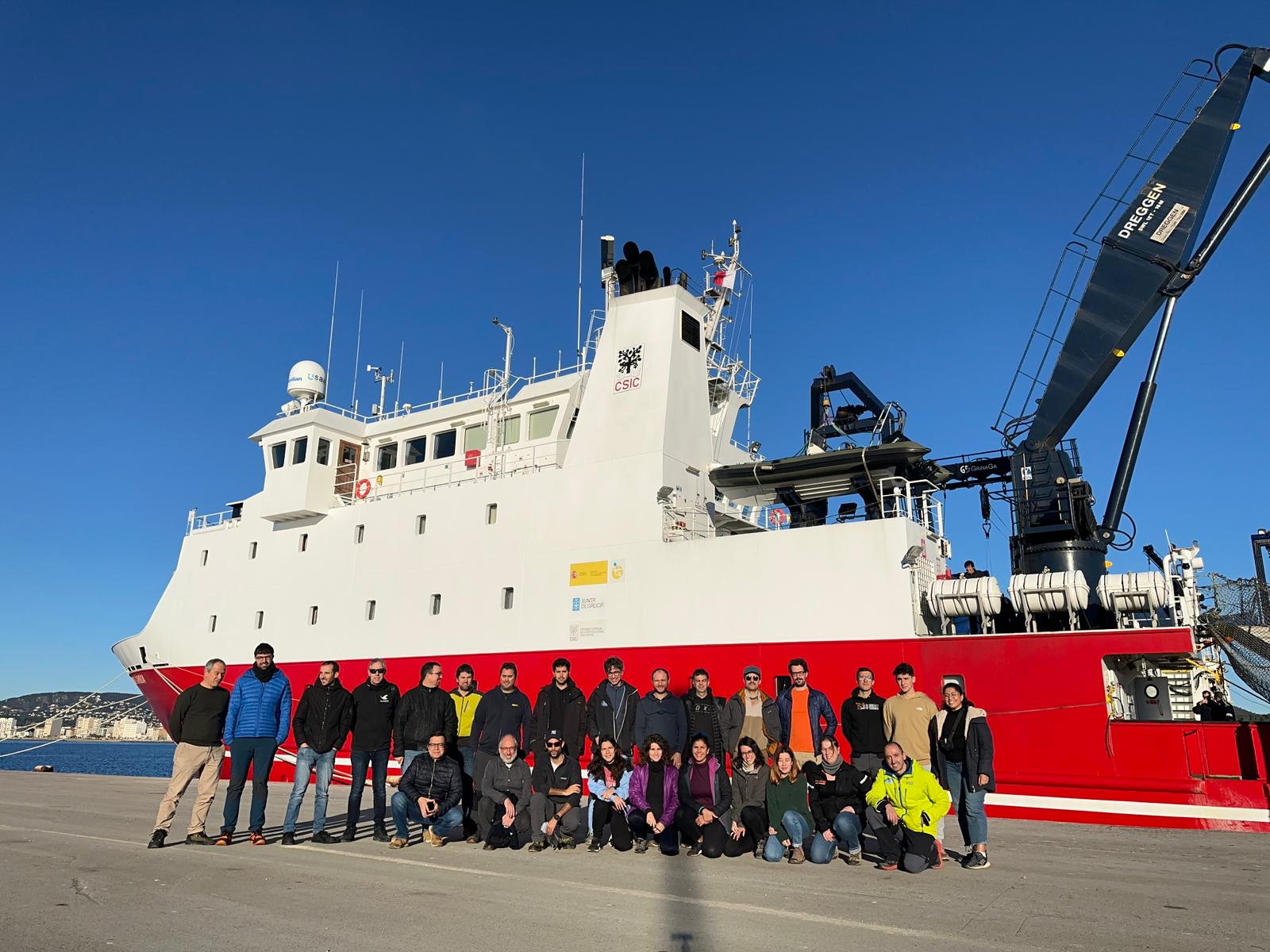
Figure 1. Members of the oceanographic campaign in front of the Sarmiento de Gamboa ship in the port of Palamós.

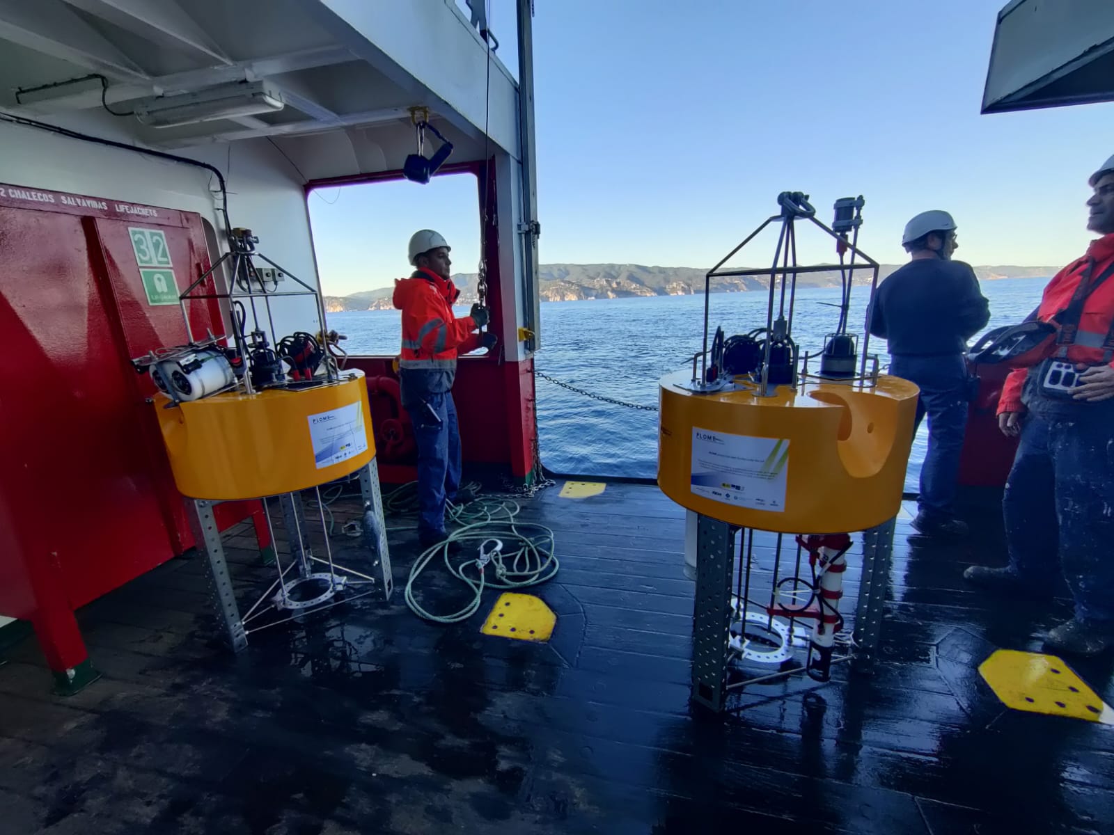
Figure 2. UPC fixed stations prepared to be placed on the seabed.

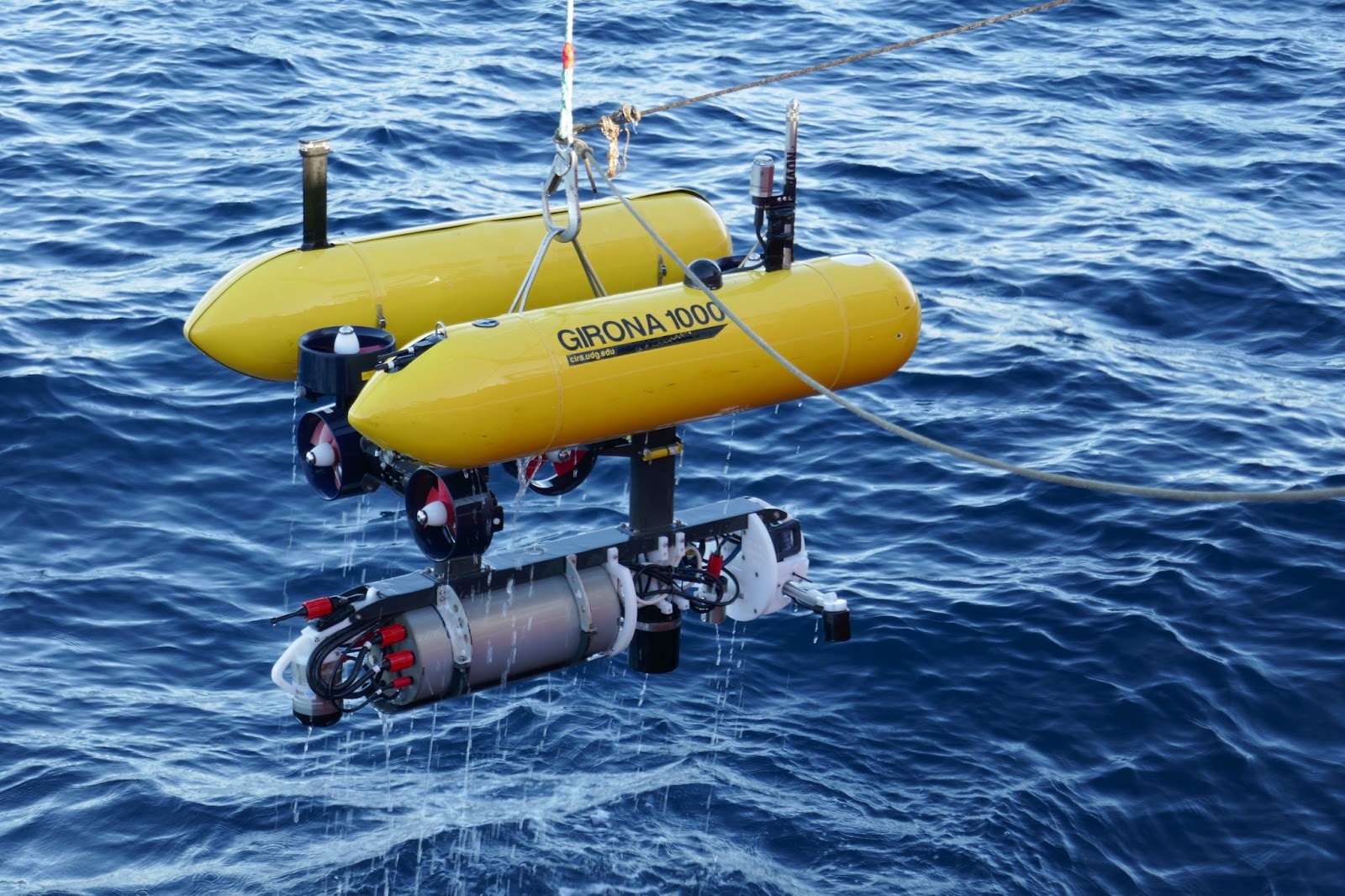
Figure 3. Recovery of the Girona 1000 autonomous underwater vehicle of the UdG.

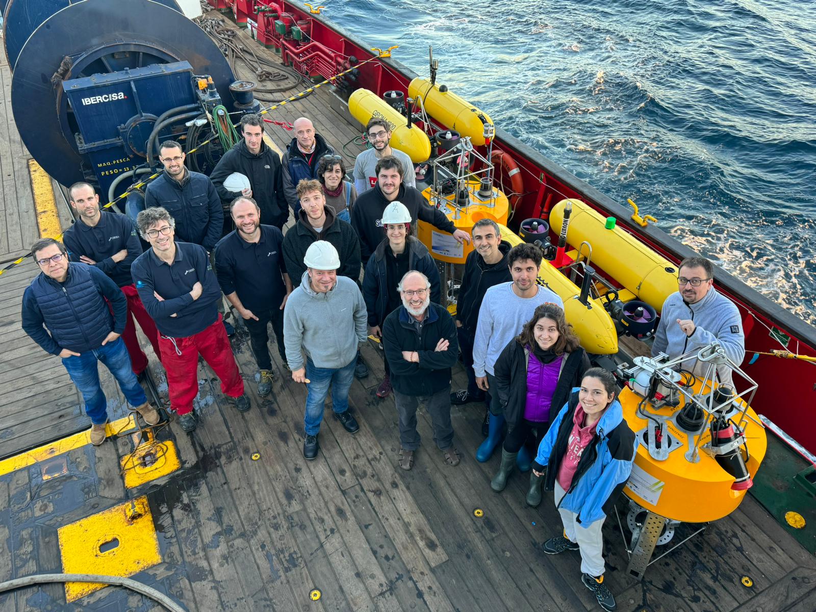
Figure 4. PLOME project work team at the end of the campaign.

Ref. PLEC2021-007525/AEI/10.13039/501100011033

Categories
SoundTiles

SoundTiles new release supports FLS data from major brands

Last April we launched the new release of SoundTiles software for processing FLS data. Besides the already supported brands:

• Sound Metrics
• Norbit

We now support:

• Teledyne Blueview
• Teledyne Reson
• Blueprint Subsea
• Kongsberg Maritime

SoundTiles is a stand-alone software solution for automatic generation of underwater acoustic mosaics from forward-looking sonar images that was launched by IQUA robotics on July 2021.

The software allows to process a set of sonar images, find the correct alignment between them and blend them in one single informative mosaic. The generated mosaic provides an overview of the surveyed area and eases the interpretation of the imaged scene, allowing the identification of spatial relationships and offering a map of increased resolution and signal-to-noise ratio with respect to the individual sonar images.

To be informed about the last developments on SoundTiles, you can now register to receive our newsletter.

Categories
SoundTiles

SoundTiles customer experience: oQuay (NL)

“The way we inspect (video mapping and imaging sonar) is quite unique in the Netherlands. The use of imaging sonar is a basic necessity for our company. Without it, we have no right to exist. In addition, we can translate the data into information that the owner can use. The combination of high quality data and thorough advice distinguishes us.” says Peter Nieuwenhuizen, CEO at oQuay

oQuay was founded in 2009 in the Netherlands. They work in environments where the water is often turbid and there is little or nothing to see in the video images. The company looked for an alternative technology to help their clients in these difficult conditions and finally ended up choosing imaging sonar technologies, specifically, the ARIS Sound Metrics sonar, which they operate from an ROV.

“We mainly inspect quay walls and bank constructions. This year we have seen an increase in the number of inspections between shore and ship. Often, this is not inspected because temporarily moving a boat is a lot of hassle or the inspection is too dangerous for divers. With our ROV we can easily maneuver in between and still perform the inspection.”

Their team is composed of four people, including: a ROV pilot, a team member specialized in processing the data and two more employees devoted to understanding the quay constructions, assess the content of the data and give advice on repairs to be carried out to the end customer.

The company recently acquired SoundTiles, an IQUA robotics stand-alone software solution for automatic generation of underwater acoustic mosaics from forward-looking sonar images. The software allows to process a set of sonar images in one single informative mosaic, easing the interpretation of the imaged scene, allowing the identification of spatial relationships and offering a map of increased resolution and signal-to-noise ratio with respect to the individual sonar images.

“SoundTiles helps us now to get panoramic pictures that help us to better interpret the situation below the waterline. You have more overview. We manage quite well to make the mosaics ourselves, making about 1 mosaic per week; the mosaics definitely have an added value to be able to see underwater.”

Categories
Announcements SoundTiles

NEW PRODUCT: SoundTiles, obtain your FLS maps in a matter of minutes

We are pleased to announce the launching of SoundTiles, a stand-alone software solution for automatic generation of underwater acoustic mosaics from forward-looking sonar (FLS) images.

The software allows to process a set of sonar images, finding the correct alignment between them and blending them in one single informative mosaic. The generated mosaic provides an overview of the surveyed area and eases the interpretation of the imaged scene, allowing the identification of spatial relationships and offering a map of increased resolution and improved signal-to-noise ratio with respect to the individual sonar images.

SoundTiles is a very intuitive and easy-to-use software, designed for end users that allow process FLS images in a matter of minutes, make annotations and measurements, and export the data in different formats. With SoundTiles the generation of FLS maps becomes a straightforward task, reducing drastically the amount of work and improving the quality of the results.

SoundTiles is currently compatible with Soundmetrics and Norbit and will soon be compatible with Teledyne Blueview, Teledyne Reson and Blueprint forward looking sonars. It can run in Windows 10 or Linux Ubuntu operating systems. The software has an in-build wizard that guides the user in the basic processing steps. It features also a set of more advanced tools for mosaic optimization, offering options for fine-tuning in order to achieve the best performance.

Image illustrating the post courtesy of Acquest Geofísica (Brazil).

This project has received funding from the European Commission under the H2020 SME instrument program.